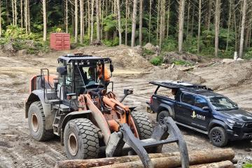
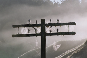
Timberlands systems transformation manager Megan Costello, who collaborated at the start of the Digitally Enabled Harvesting project with Eagle Technology, says having an internet connection within the forest would bring benefits at different stages of the log production cycle such as felling, processing and loading.
Faced with the challenges posed by Cyclone Gabrielle, Fire and Emergency New Zealand (FENZ) recognised the need for improved coordination and decision-making across emergency response agencies. Leveraging Esri's ArcGIS toolset, FENZ established a Common Operating Picture (COP) to facilitate data sharing among government agencies to improve the widespread response and recovery efforts.
An inspiring community-led programme to revitalise the health of the Little Waihī estuary (Pukehina), one of the most degraded in Aotearoa New Zealand, is taking place in the North Island's Bay of Plenty area.
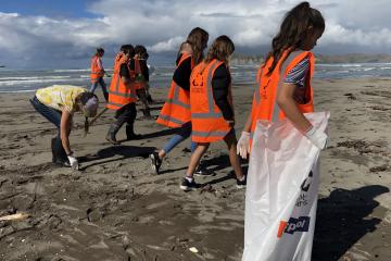
The town of Gisborne, New Zealand, located on the east coast of the northern island, is endowed with stunning waterways and beaches. But as in most beach towns these days, residents and visitors often see trash strewn across the sand.
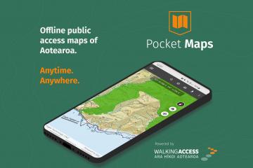
If you’re a hunter, angler, or tramper out in the field, being able to access portable maps that show whether you’re entering public or private land is crucial for safety and peace of mind. Users of the New Zealand Walking Access Commission (NZWAC) maps could access them only via a web browser – there was no offline portable version of the maps.
Miraka uses ArcGIS to enable bespoke environmental plans
Miraka is a Māori-owned organisation with a history of innovation and a focus on making decisions that reflect a long-term view. Miraka exports its premium milk products globally and its goal is to become the world’s most sustainable dairy company.
Lucas Associates launches interactive native plant guide
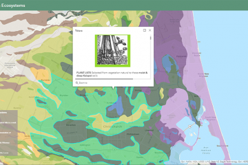
The digitised Ōtautahi Christchurch indigenous native plant guide and ecosystems app has been a 26-year labour of love for Christchurch-based landscape architect Di Lucas of Lucas Associates. Di has been involved in identifying the different ecosystems of Canterbury and providing lists of native plants belonging there. Now the data has been captured in a web mapping application via ArcGIS.
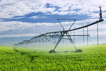
Tapping into the data collection, spatial analysis and smart mapping visuals offered by Esri ArcGIS tools has enabled Powerco to ensure that the right assets are repaired or replaced at the right time in the right locations. In 2018 Powerco began to carry out a substantial five-year renewal programme. The ways in which ArcGIS tools are being applied to this programme of work are constantly being expanded
Pāmu and Esri help solve winter grazing challenges
When Southland farmers came under the media spotlight for wintering practices in 2019, Pāmu’s Geospatial Services Manager Bronwyn Rodgers recognised that part of the solution would lie with GIS.
When New Zealand entered Alert Level 4 lockdown at short notice in March this year, WEL Networks’ vegetation management team was well-positioned, having already gone digital in January 2020.
Miraka harnesses innovation in geo-spatial mapping
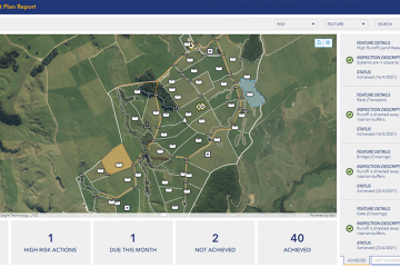
Miraka’s goal is to become the most sustainable dairy company in the world. In a first for the industry, the company has rolled out farm-specific carbon emissions reports to each of the over 100 farms they work with. They also supply each farm with bespoke farm environmental plans, incorporating geospatial mapping tools provided by Eagle Technology.
New Zealand is considered high-risk for almost every possible catastrophe: Earthquakes, Floods, Volcanic Eruptions, Wildfires, Landslides, Tsunamis, Droughts and Cyclones are all hazards to various parts of New Zealand.
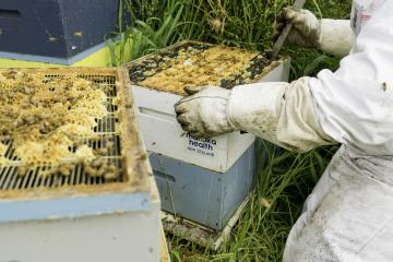
Delivering innovation to the bee sector through digital mapping
Manuka Health New Zealand, one of our largest manuka honey producers, based in Te Awamutu, has taken its beekeeping operations to new levels of efficiency by using a mobile GIS (Geographic Informat
NZTA possessed end-of-life infrastructure which was proving cost prohibitive to replace. The agency wanted to enable its geospatial platform to be easily leveraged by agency-wide systems to prevent siloed platforms and siloed data. Eagle designed and delivered a complete managed service for NZTA’s geospatial platform. In collaboration with other vendors, Eagle upgraded the agency’s entire geospatial platform and migrated it to the cloud using Microsoft Azure.
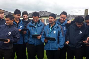
Youth Search and Rescue (YSAR) uses innovative technology in search and rescue and emergency management.
Tauranga's Youth Search and Rescue organisation uses the Esri ArcGIS Platform, Systematic Sitaware Command and Control systems with Motorola radios and Radio network components to keep its young people safe when training in diverse outdoor environments.
Whakatane: State of Emergency Flooding Incident April 6 2017
When floodwaters breached the banks of the Rangitaiki River , a mapping portal was created in a collaboration between the GECC and the EOC in Whakatane involving GIS staff from WDC, BoPRC, Tauranga City Council, Western Bay of Plenty District Council, New Zealand Urban Search and Rescue and external GIS consultants. Web mapping applications were quickly configured for incident intelligence, welfare assessment, building assessments and transportation updates.
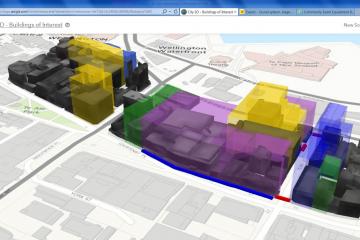
In this emergency situation geospatial tools used in conjunction with 3D data enabled the Wellington City Council to evaluate what was happening in the city and to analyse, communicate and act across its Emergency Operations Centre.
Downer had a need for GIS tools across its businesses to create greater efficiencies in its operations. By signing a special licensing agreement with Eagle Technology Downer gained access to the full range of GIS tools to systematically apply and adapt over its diverse range of businesses.
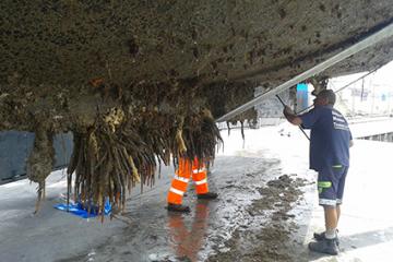
Using ArcGIS Collector and iPads, Biosecurity officers and GIS staff at Northland Regional Council have stepped up efforts to control the spread of Mediterranean fanworm on the hulls of boats and equipment.
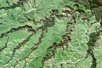
The need for accurate landcover information is a vital component of the TBfree programme. ENVI's remotely sensed data assists in the effective monitoring of possum-spread disease.
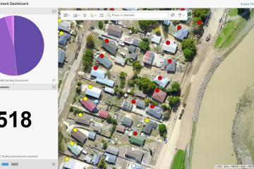
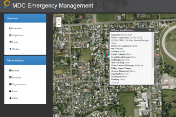
MDC’s ERBA (Emergency Response Building Application) empowers field crews and command centres to pinpoint areas of injury / damage and assign resources accordingly.
Using ArcGIS technology, Eagle Technology helped to build a Situation Awareness Tool, or SAT, that allow operators to see graphs, heat-maps and geographic displays to create generation dispatch schedules, moving electricity seamlessly and a the lowest possible cost.
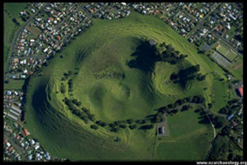
GIS and Eagle Help Preserve NZ’s Archaeological Heritage
Abstract Preserving our archaeological heritage is a matter of national importance. But in order to protect that heritage, archaeologists, local councils, the NZ Historic Place Trust and other stakeholders need to know where archaeological sites are located, their extent and condition, potential threats and ownership.
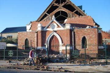
First responders need to know which buildings have been damaged, which buildings contain hazardous substances or critical infrastructure, the status of water and wastewater services, which roads are open, where shelter, water and toilet facilities are located and a host of other questions that need answers. In Canterbury, in the aftermath of the 7.1 magnitude earthquake on 4th September 2010, GIS (geographic information system) provided the answers.