GIS Technology for NZ Agriculture
GIS Technology for NZ Agriculture
Agriculture is one of New Zealand’s leading industries, employing thousands of people and contributing to a significant portion of the country’s overseas trade. With this scale, it is unsurprising that regulation is increasing as part of ensuring that economic gains of agriculture do not come at too high a cost to the environment alongside an increasing consumer desire, both domestically and overseas, for sustainably produced food.
Given this increasing pressure and intensity, there has also been a huge increase in the number of apps created for the sector over the last few years. These apps range from those provided by large sector players (such as the fertiliser providers) to those created by small, focussed start-ups, but what has been particularly interesting is that almost all of these have spatial technology embedded inside in some form. While this spatial technology ranges from dropping a map in the corner of the user interface for context, to having full spatial analysis using machine-learning, it does reinforce the importance of location to those whose work is intrinsically linked to the land.
Eagle Technology’s own work in the agriculture sector is focused upon using location for connecting otherwise disparate datasets, producing insightful and compelling maps and connecting users across organisations.
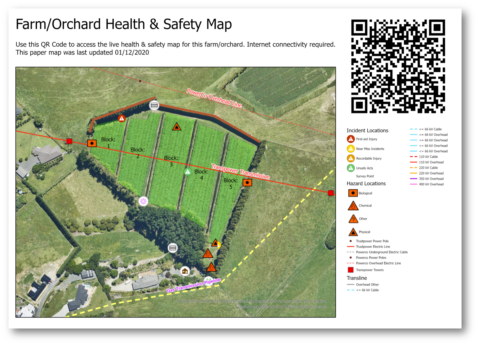
Map Images represent demonstration data only
We recognise that in agriculture especially, key decisions are being made at a national, regional, local and paddock level every day and that these decisions affect both the environment and the viability of farmers’ businesses. Therefore, having connected and data data-driven tools, combined with accurate and authoritative sources of data in the hands of all decision-makers is key to achieving the best outcomes.
This is work we have been doing for many years through providing ArcGIS solutions and while there has been a great range, both in scale and scope, of ArcGIS applications, they can be summarised into 5 key areas:
- Mapping & visualising all farm-related data – bringing data in many forms into the GIS as a “one-stop shop” live view of farm operations and assets. Alongside the farmers' own data, data sources include external sources from councils, satellite imagery, slope, land parcels and other data which is included inside ArcGIS.
- Better understanding crop health & productivity – using various location-based data sources within blocks/paddocks (yield/pests/quality) to visualise and model the health and productivity of crops and/or livestock.
- Monitoring farms with sensors & drones – capturing data in near real-time which allows us to understand how things are changing across the farm and connecting these to other data layers.
- Improving compliant & sustainable practices – supporting land stewardship through identifying, reporting, and mitigating issues with simple to use apps and reporting tools that combine to give a living record of the land.
- Making our farms safer – promoting safety through awareness of hazards as well as easy reporting of incidents and hazards using apps while also supporting data sharing between systems.
Across all these areas there is also a range in the levels of complexity or sophistication. For many applications, the key is using proven technology configured to the specific workflows and environments of the agricultural sector. Mobile technology is a good example of this where we have seen great benefits through taking the next generation of Esri's field apps and dashboarding tools out onto farms, capturing everything from health & safety hazards or farm assets and measuring crop health or fruit quality. Another is access to high-quality, accurate data such as Eagle’s Imagery Basemaps which can be taken offline using the apps and which can be augmented to be even more up to date by adding premium imagery from our Planet, Maxar and Nearmap data partners.
At the more “cutting edge” end of the spectrum, here at Eagle Technology we’ve been involved in some pretty exciting areas, including integrating ArcGIS with blockchain to support provenance use cases; as well as the great work being done with advanced image analysis and deep learning – using satellite and aerial imagery to understand variables such as nitrogen levels or soil moisture.
One recent and significant change is how all of this capability can be consumed. This has come about with the introduction of ArcGIS Platform. This is a developer-focused business and technology model designed for those who wish to geo-enable their own technology with the rich ArcGIS capabilities but without turning their application or licensing models into an actual GIS. Allowing you to use basemaps and analysis on a consumption basis and to use this with other non-Esri mapping technologies such as Leaflet or MapBox.
Of course, none of these approaches are mutually exclusive areas and one of the major benefits of using a system like ArcGIS is joining the dots of apps, data and workflows: allowing data to be easily captured and analysed and then made available via apps, dashboards and WebMaps to decision-makers, all in near real-time – a pattern we are increasingly seeing on farms, vineyards and forests across New Zealand. Alongside this is the current work being done by AgriTech NZ around spatial data interoperability between systems – work which we at Eagle are heavily involved in and see as unlocking some real opportunities for data sharing between systems.
To learn more about the developments in this area come and see us at the 2021 Fieldays stand or check out the Eagle Technology AgTech Page.
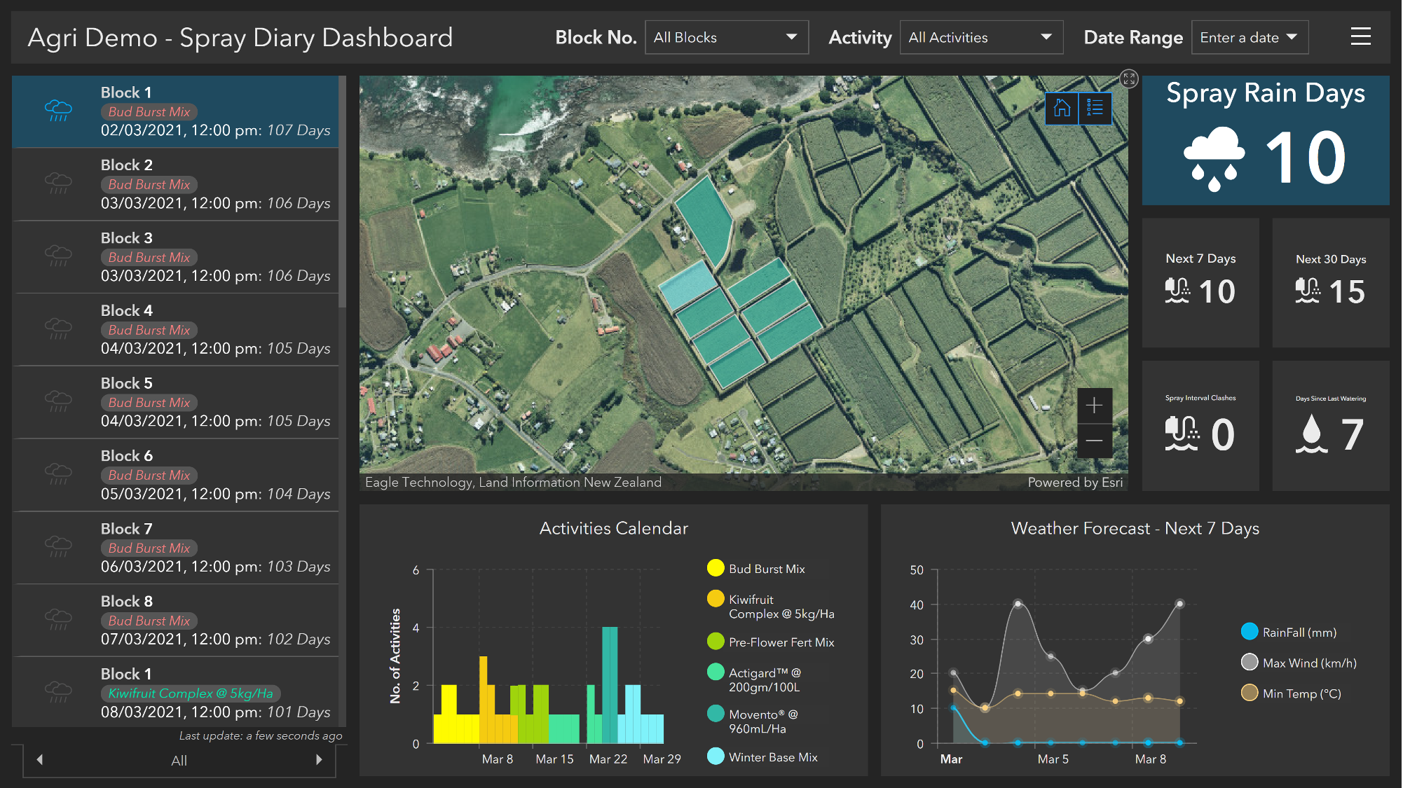
Map Images represent demonstration data only
View all blog posts