
 |
 |
|
| Di Lucas | Leona deRidder |
The development of the digitised Ōtautahi Christchurch indigenous plant guide and ecosystems app represents what has been a 26-year labour of love for Christchurch-based landscape architect Di Lucas of Lucas Associates. Starting with South Canterbury in 1981, Di has been involved in identifying the different ecosystems of Canterbury and providing lists of native plants belonging there. Now the accumulated Christchurch data has been captured in a web mapping application via ArcGIS. In March 2021, this interactive ecosystem map went live on Christchurch City Council’s website.
How it all began
From the mid-90s Lucas Associates had provided maps, booklets and sets of 21 different plant lists through Council offices. Much of this hard-copy information disappeared following the city’s earthquakes.
Di Lucas ONZM, well-known as a passionate advocate for our landscapes and the landscape architecture profession, has now taken this ecosystem information a step further. She has privately funded the development of an interactive ArcGIS app containing all of this information and has gifted it to the Christchurch City Council. From March 2021 this precious resource became freely available for public access.
In 1993, as part of a project commissioned by the Canterbury Regional Council, Lucas Associates contracted Manaaki Whenua-Landcare Research scientists to identify the different land types across Canterbury to provide a framework of broad ecosystems that recognised underlying character. In 1995 Lucas Associates was commissioned to build on this original work by community boards, through the Ōtautahi Christchurch Agenda 21 committee, which promotes the need for greater native biodiversity around the city. Di Lucas again contracted Manaaki Whenua-Landcare Research, working with geomorphologist and soil scientist Ian Lynn and ecologist Dr Colin Meurk.
The city was divided into four land systems – dry plains, wet plains, coastal, and the Port Hills. Based on soil types, each land system was further divided into an ecosystem typology that honed in on the soil types and biota of Christchurch, using street maps as a base to seriously explore what’s naturally local.
‘I knew that Christchurch has not been “just a flax swamp”. I wanted the public and designers to be able to understand more about the underlying natural diversity,’ says Lucas.
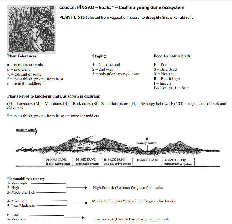
From remnant vegetation and historical data, each ecosystem was named to cue to the underlying land and particular biota that belonged there naturally. For example, on the wet plains, the ‘kahikatea, kererū, manatu, lush older plains ecosystem’, and on the dry plains, the ‘kōwhai, pipit, mikimiki, young plains ecosystem’. A signature graphic was created for the biota of each ecosystem, along with a diagram showing the character of the land below. Colin Meurk then compiled lists of native trees, shrubs and groundcovers that would have grown naturally in each of the ecosystems.
For each ecosystem, information on each species’ site preferences or tolerances is noted. Thus, tolerances to wetter or drier, sunny or shady, or of windy conditions, is identified to help people to plan the most appropriate planting locations. This can ensure the right native plant is planted in the right place. As many projects begin with open sites – whether paddock, lawn, park or bare ground – there is also guidance on staging plantings to achieve long-term success. This means the colonisers, the first-stage plants, are planted, followed by the species that prefer to be established under their shelter and shade.
‘Often people are in too big a hurry to establish the ultimate cover, when the best success rate will result from staged plantings to create the right microclimate for the main species. As a bonus you can shade out weeds along the way!’
Lucas is excited that this long-term information project has now been given a new life in interactive form on the Council’s website. ‘I hope that it will inspire people to take greater interest and care in planting what’s most suited to their particular area.’
The fourth and final component of the ArcGIS web mapping application, which will cover the hills ecosystems of Christchurch including the Port Hills and hills around Te Whakaraupō, Lyttelton Harbour, will be added soon.
‘But of course it’s never “finished”, as more information comes to light, or the taxonomists change some plant names again. Many of the botanical names have been changed over the 26 years since we started the lists,’ says Lucas.
However, common names which may be easier for people to recognise, have also been included in the lists.
Getting Eagle Technology involved
Di involved her colleague landscape architect Leona deRidder to manage the process of converting the information gathered over the previous 26 years by Lucas Associates into a geospatial app. DeRidder approached Eagle Technology to create an ArcGIS app customised for purpose.
‘To my knowledge this is the first time that data about local native plants, soils and ecosystems has been captured and built into a GIS application,’ says Eagle Account Manager Ted Taylor.
‘Leona deRidder and Di Lucas recognised an opportunity to put together a sophisticated yet simple solution with Eagle Technology’s assistance,’ he says. ‘ArcGIS had the capability to put their years of hard work and research and that of Manaaki Whenua-Landcare Research scientists into the public domain for the benefit of all Christchurch property owners, designers, educators and plant nurseries. I’m very pleased we were given the opportunity to work alongside Di and Leona to bring their vision to life.’
Why the interactive plant app is so important
Leona deRidder says that if people use the data in the app to inform their planting it will help to encourage more local native plants. Canterbury and Christchurch have so little vegetation to tell the stories of the nature of the area. Local natives can also be used in interesting design styles, including confined or formal styles, and not merely for a naturalistic style or the restoration of nature. Plantings can also link up odd patches that do remain, creating ecological linkages.
‘For landscape practitioners this new interactive app means that it’s now much easier to find out instantly the type of soil and the microclimate in which particular plants belong to each specific area of Christchurch,’ says deRidder. It’s a great tool not only for landscape designers but also for park planners, private gardeners and teachers. The new interactive map reveals a whole ecosystem. There’s also information about native birds and lizards and what plants they like to eat. People want the plants and shrubs they buy to be able to flourish. This provides guidance for them. We hope that nurseries and garden centres will be proactive and stock more local species, preferably propagated from natural remnants
– eco-sourced.’
Being able to access this live interactive app of indigenous flora and fauna will help local residents to understand more about the different soils and indigenous vegetation in and around Christchurch.
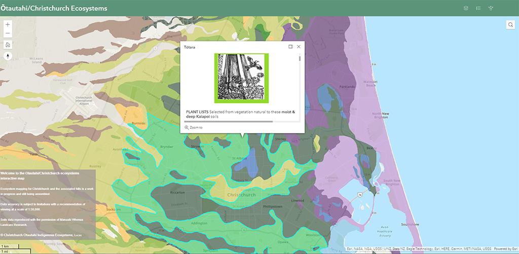
Users click on the interactive map on the Christchurch City Council website, or type in their address, to find out which ecosystem their site belongs to, sourcing a list of plants native to that site. They can then print out a ‘shopping list’ to use in their design and take it to a nursery or garden centre and avoid the usual haphazard planting of trees and shrubs that don’t belong in the particular soil type and microclimate of their area or their street.
‘I hope that Christchurch residents will gain a better understanding of their place and will use more local native plants. Using the native plants adapted to the locality means they will more likely thrive,’ says Lucas.
‘We recognise the impact of climate change is challenging the ability of plants to withstand different conditions. There is now greater stress on all living plants and animals. If people understand the ecosystem in which they live they can choose the most drought-tolerant species for their increasingly dry area, or select those that withstand inundation from increased flooding for flood prone sites.’
Climate change has also led to increased fire risk, as the February 2017 Port Hill fires showed when 1600 hectares of land were burnt. In 2021 high, medium and low fire-proneness has been added to the plant lists for the interactive map, so that people can be guided in selecting low flammability species for green firebreaks where that is appropriate. Azharul Alam has assisted Lucas with this task, having recently completed his PhD on flammability at Lincoln University.
Lucas and deRidder urge local bodies around New Zealand to step up and create similar geospatial native planting resources unique to their own regions. With so many native plant projects being promoted, it would be extremely useful if there was more information available to guide people as to what is native to their area.
Visit the Ōtautahi-Christchurch ecosystems web mapping application: https://ccc.govt.nz/environment/land/ecosystem-map
Summary of benefits
- People will gain a better understanding of the indigenous trees, shrubs, etc belonging in their specific environment.
- People will be inspired to use more local native plants.
- If the right native trees and shrubs are planted they are more likely to survive and thrive.
- Less time and money will be wasted in ad hoc planting of inappropriate trees and shrubs for the conditions.
- People can find out which native plants are best suited not only to their area but even to their particular street.
- The interactive mapping application is simple and easy to use by anyone with access to the Internet who visits the Christchurch City Council website.
- The Ōtautahi Christchurch indigenous ecosystems guide can function as an inspiration not only to gardeners and landscape designers but also to other local bodies who may be galvanised to fund the same type of digital plant map resource for their own residents and to guide professionals.
ArcGIS products used:
- ArcGIS Online
- ArcGIS Pro