75+ Key Benefits that make Geospatial Technology Unique
The following article is an extract from the ‘Eagle Technology Geospatial Benefits e-Book’
Part 1: Introduction
Many organisations struggle to explain to executives or other stakeholders how geospatial technology helps that organisation achieve its stated mission and objectives. Geospatial technology is no longer simply about 'making maps’; it is now a critical component and system that underpins a range of business activities.
To aid our clients as we work with them on strategic initiatives, we have created a unique framework for geospatial technology's key business benefits. Key points to note:
- This framework focuses on the 'unique' benefits of geospatial technology. While some of the individual benefits can be shared with other technologies (for example 3D functionality is also a feature of CAD systems and gaming software) when several individual benefits are taken together, they provide the unique set of capabilities that geospatial technology provides.
- This framework is not intended to be about individual geospatial functionality, software modules, or tools - there are too many of those to fit into a simple framework; nor is the focus about specific ways that different datasets can be combined for different industry sectors (otherwise the framework would be virtually endless!)
- This is an ever-evolving framework because the benefits of geospatial technology are continuously evolving, therefore we will update this framework and associated material on a frequent basis.
- This framework is intentionally written in ‘plain language. Where possible we have attempted to avoid technical jargon to make the information widely accessible and useful for education.
When applied properly, strategic planning requires a robust and proven approach. This is important as every organisation has a different set of objectives, goals, strengths, and weaknesses when compared with other organisations. As such, each individual organisation is unlikely to gain (or even need) all the benefits indicated below. Therefore, the Eagle Technology Business Consultancy Team has a very structured approach to focus on what benefits are important for our clients. We have developed and maintain a core knowledge database and template catalogue to deal with many aspects of strategic planning – the following framework is one of several interconnected datasets within that database. Our experienced personnel use these resources to create techniques to simplify, tailor and enhance strategic planning activities.
For more information about how Eagle Technology can assist your organisation with Strategic Plans and Business Cases see:
https://www.eagle.co.nz/consulting (New Zealand and South Pacific Nations only)
More explanation of the individual items are included in our Geospatial Benefits e-Book (see link at the end of this article).
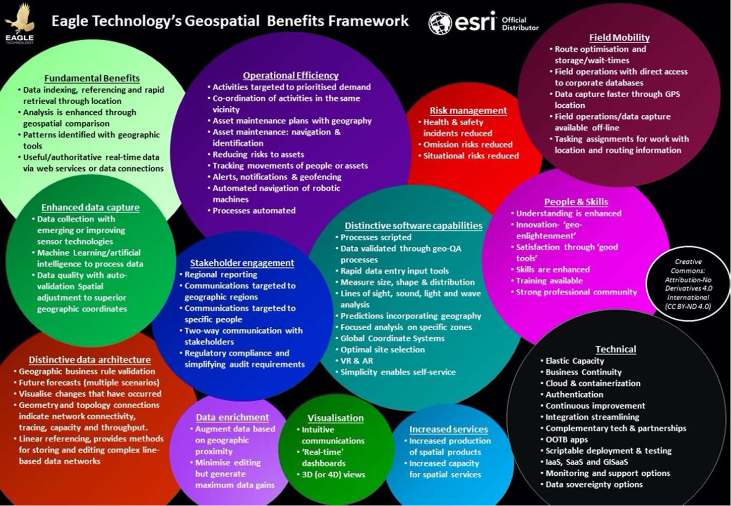
Part 2: Benefit Classes
The benefit types in the framework are grouped into ‘benefits classes’, as explained below:
 |
Operational Efficiency |
 |
Field Mobility |
 |
Data Enrichment |
 |
Enhanced Data Capture |
 |
Stakeholder Engagement |
 |
Visualisation |
 |
Risk Management |
 |
People |
 |
Distinctive Software Capabilities |
 |
Distinctive Geospatial Data Architecture |
 |
Increased production of geospatial goods or services |
 |
Technical Benefits |
These benefits classes, with expanded information about the benefits types, plus examples of each ‘in the real world’ are available in the e-Book: Eagle Technology: Geospatial Benefits Framework.
For more information about how Eagle Technology can assist with Strategic Plans and Business Cases for your organisation then please contact us: (New Zealand and South Pacific Nations only)
This framework and associated material is released under Creative Commons: Attribution-No Derivatives 4.0 International (CC BY-ND 4.0)
 |
 |
 |